

Plans and Progress
We need clarity about what plans in Madison matter. Just because it makes it on paper and is "adopted by Council" does not mean it will be built. This is what we are witnessing at Regent Street.

I started paying attention to local government as a college student. I was tired of how little control I had over national politics and I realized that local government was more accessible than I thought. With COVID wreaking havoc on local businesses, I subscribed to the Wisconsin State Journal and began to read up on the city I hoped to make a permanent home after graduation.
I was spurred into action after reading about a historic preservation claim over The Wonder Bar, a supper club with a 1920’s aesthetic. The owner sought an exit from the business and by virtue of the nearby neighborhood being in an appealing area, they wanted to close the restaurant and sell to a developer. The developer proposed building an eighteen-story apartment complex just down the road from the Capitol and downtown. This story is not a focus on that debate of preservation and development, but instead a glimpse into the system of how we make progress in city government.
As a newcomer to local governance, I would have sent a comment to Plan Commission in support of the project. But I didn’t know that process yet. As a graduating student, I was looking at rent increases throughout my four years and I was worried about rents continuing to rise. Madison was a growing city and continues to grow, which heightens the need to meet housing demand. I also believe that infill housing projects in areas where people want to live is better for residents and less costly for the City than sprawling to new land. Taking an underused restaurant, bar, and parking lot and putting up hundreds of units was a huge win for the City. This would be at the expense of neighbors who didn’t want the traffic and new tenants and the preservationists who felt like they would lose something historic.
Despite housing goals and a desire from the land owner to sell and the developer to build, the permits were denied. The building needed to be preserved if development were to go forward. This huge cost has left the site undeveloped, even after multiple attempts to scale down the project, and it is covered with graffiti and plywood as it atrophies away. This is the result of ordinances dictating what can be done in the face of the plans we adopt that say what we should do.
There are so many plans
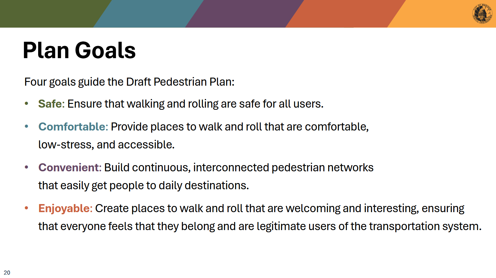
Common Council will receive a set of draft transportation related plans to adopt later this summer: the Pedestrian Plan and the All Ages and Abilities (Bike) Plan. These documents cover goals that the City hopes to accomplish on the scale of decades. The last pedestrian plan passed in 1997, if that gives you a sense of how long these cover.
There are many aspirations:
With the current mayoral administration and council covering this general sentiment in Madison, it makes sense to prioritize these!
How many of these priorities are implemented? How are they implemented? What goals or objective achievements can we point to and say “we will get this done by 20XX and it will be through this law”?
Very few. And the reason is that these plans are not legally binding. It gives the City direction, which is important. City Staff should understand what it should be working on and how it might achieve it. It also gives the City flexibility; things can change rapidly (a recession, a new technology) and legally requiring changes with deadlines can be dicey.
My concern arises when departments either:
Write goals that are in active conflict with other departments, with no means of reconciling differences in approach
Have no means to enforce or implement goals when the time is right
It’s important to remember that City Staff is an entity of diligent workers who aren’t (necessarily) aligned or incentivized by the same standards. They all must follow existing ordinances and they all must report to the Mayor. But often, there are different objectives and ways of thinking that reveal the flaws in plans as they are adopted. In writing this piece, I am asking:
Who are these plans for?
Are these plans going to accomplish what they set out to do?
Conflict and Incentives
The most apparent conflict between departments for me is the authors of the Complete Green Streets Guide (CGS) and the Traffic Engineering department (which may be the same people!1). Earlier this year I wrote about the reconstruction of Regent Street. This is a corridor of small businesses and a hospital complex located near dense student housing and a well-established Vilas neighborhood. It’s also one of the few East-West streets near downtown and is often used by commuters who don’t live in the area.
Our successful lane removal trial for Willy Street posed the following question for traffic engineers: do we need peak-hour lanes for Regent? If Willy revealed we didn’t, can we reduce a four-lane intersection down to two in an area where hundreds (if not thousands) of students cross each day to get to classes?
The initial answer was yes, we can. The “preferred option” put an emphasis on pedestrian comfort and safety, expanding really uncomfortable sidewalk widths from 5 feet to 9 feet. This is a win and I’m happy that City Staff quickly adopted the results from Willy into a needed infrastructure upgrade project. Walking along Regent Street as a student was always uncomfortable. Making things walkable will likely increase foot traffic and make the local businesses more appealing too.
From here though, we can see where different mandates and incentives diverge. There was prominent discussion of a 28 foot clearance width for traffic at a Transportation Commission meeting. It was later revealed that this stems from the Madison Fire Department’s request to be able to easily maneuver through traffic (caused by vehicles) and have enough room to deploy all equipment from fire truck engines during an emergency. Meriter Hospital (a Level II trauma hospital) is also located nearby and representatives emphasized the need for ambulances to have easy access through the corridor. City Staff deferred to these requests and built large intersections with only a limited reduction in parking and loading spaces (what the lanes were when peak-hour lanes were not in *effect*). Outside of safety concerns, most businesses also expressed concerns with losing parking and loading access, so this likely informed some decisions as well.
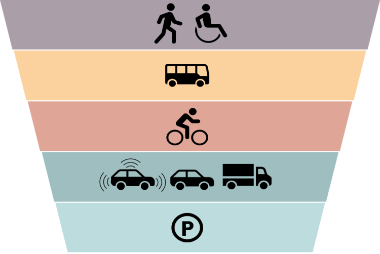
The problem is, these recommendations are in conflict with CGS! There’s a modal hierarchy that puts pedestrians first, then transit, then bicyclists, then vehicles, and finally parking. The plan as is offers compromises to pedestrians when convenient for vehicles, but no sacrifices as would be required. The hierarchy is vehicles first, parking, then pedestrians (with lowly bikers at the bottom). At the most recent Transportation Commission, Tom Mohr (who is representing the City at these meetings) is able to answer clearly when vehicles will be impeded but is unable to answer questions about how pedestrians will be impacted. These should be swapped!
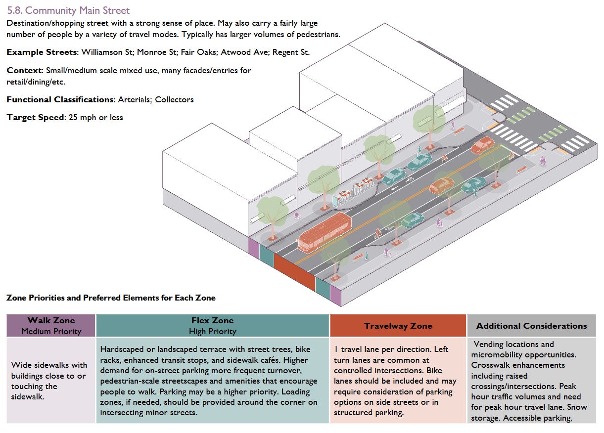
In an ideal CGS street, this business and housing corridor would be built out so people could safely live, work, and shop with ease. That includes larger sidewalks, but also mandates safer intersections for crossing. Crosswalk widths would be closer to 20 feet rather than *28 feet* and there would be infrastructure to protect pedestrians and slow down vehicles. It would also look towards adding bicycle infrastructure (as a higher priority mode in the hierarchy). Bike infrastructure was shot down because it put vehicle throughput at risk. Commuters wouldn’t be able to get through without waiting for lights. Large fire trucks and ambulances wouldn’t be guaranteed to get through congestion caused by vehicles. Businesses wouldn’t guarantee that their customers or employees would have cheap (meaning “free”), available, close parking at all times. Regent Street is designated as a “Community Main Street” per CGS, and yet many of the priorities are outright overruled:
What’s the purpose of CGS if City Staff can develop streets and not consider it? Is it to solely appease citizens who think that pedestrian safety is a more important and higher risk than fires in our advanced world of fire risk prevention2? To calm the “bike mafia” who want serious implementation of safe bike infrastructure rather than “sharrows”?
Is it to try and provide a lodestar for staff, but in reality allows them to pick and choose when there’s an opportunity to use the standards and conveniently ignore them when there might be political hay from drivers that don’t want to be slowed down in a people-focused area?
Ah, but here’s the bait and switch! Staff did consider the guide, as Mohr explains at a Board of Public Works meeting (34:25-42:00) on a Wednesday night (4/22/26)3. CGS has overlay districts and those allow staff to consider parking as a higher priority. In fact, Regent is one of the small business districts where parking has been considered a higher priority in the past!


This is despite community surveys returning “parking” as the least important priority for this specific project, but that’s the point of these documents. Staff want flexibility (which is normally good), and in this case they are ignoring statements like “bike lanes should be included and may require consideration of parking options on side streets or in structured parking” because the qualifier is should and not shall or must which do appear in CGS. In the end, the guide exists to help weigh tradeoffs and make decisions amidst competing priorities. Mohr decided that a (limited4) better pedestrian experience and adequate delivery and parking for business was more important than bike lanes.
Plans shouldn’t be built this way if there’s no enforcement mechanism. We shouldn’t put in the hundreds of hours of staff time to write, deliberate, listen to feedback, and rewrite these ideas if they solely exist to be on the shelf when someone cares to reference it. When the City commonly refers to the modal hierarchy in most planning documents, and yet we have qualifiers and footnotes that limit its applicability, that’s a plan that’s failing to serve residents. It is saying one thing that most people agree with and allowing loopholes when fewer people are watching.
There’s clearly an understood reference for designing these streets that the Streets Engineering departments uses and we should be reviewing that for improvements rather than developing a “break-if-convenient” set of ideas.
Ordinances, Ordinances, Ordinances
Thankfully we do have that. It’s the written laws of our City. They exist in the code of general ordinances and a few additional documents like the Comprehensive Plan and federal legislation like the ADA. When push comes to shove, these are the guidelines staff needs to follow. It’s the law!
The Pedestrian Plan highlights the need to build more housing options that make areas accessible for residents. In my mind, one of the easiest ways to do this is to allow more housing in areas that are pedestrian friendly. Pedestrian friendly means sidewalks, safe and short crossings, infrastructure that slows vehicles, and places you can walk to (schools, places of worship, shops, restaurants, workplaces). These all relate to the physical world: you put in sidewalks, you add bump-outs to shorten crosswalks, you put in medians or roundabouts to slow vehicles, and you make it possible to build buildings close together.
Within this plan, the options to increase map walk-ability with housing are as follows:
Evaluation of sidewalks for reconstruction and resurfacing
Requiring sidewalk design to adhere to the Complete Green Streets Guide
Include sidewalks on both sides of all streets (and add missing sidewalks as part of street projects)
Encouraging (not requiring) Area Plans to adopt pedestrian-friendly development and land use patterns that build a better pedestrian network
Require developers of new subdivisions to install sidewalks or other facilities at a subdivision’s perimeter
This is an important mindset, but it doesn’t prescribe a fix. There’s nothing beyond, “we should build more housing that’s convenient for walking.” How do we do that?
In my mind, you could lower lot minimum requirements (area and width, but also setbacks), so you can build more homes or businesses in a location. If you require 50 feet of lot width and 30 foot setbacks for a single family home in SR-C1 zoning, you can get 12 primary home facades per city block (average block width is 660 feet). If you instead use TR-VR2 rules and reduce this to 10 feet among other changes, you can increase the number of homes by nearly 300% (44 homes). And that’s trying to maximize the space, there’s a large threshold between 12 and 44 homes, but you need to allow people to explore that gap. It doesn’t require that the homes be bulldozed and redeveloped to those standards the next day. It provides options for owners or entrepreneurs in the future.
Madison has a housing goal of building 15,000 homes by December 31st, 2029. It’s an ambitious goal of 3,000 homes per year. There are large apartment complexes to help take on the brunt of this work, but not everyone wants to rent in Madison. There are families that are looking to have options near schools. And seniors who want to downsize from their multi-bedroom homes (and cash out a nice return on their investment) while remaining in their neighborhoods. Unless we want to play “pull up the ladder”/musical chairs and force some people to move out of Madison5, we need the legal capability to build infill housing. That started with ADU reforms and making duplexes by-right. But it can’t stop there. We will need starter homes for new families who don’t have a ton of capital to buy $500,000 homes. We will need smaller homes for seniors who are not as mobile. These smaller, inexpensive homes cannot physically be built because they are illegal in the most common zones in Madison. This is the first of the three-legged housing stool that should be fixed (the other two are finance and labor capability that can develop once you allow for the newer construction types).
Reducing lot minimums from 6,000 sqft to 2,500 sqft is a tried and true policy win in states and cities across the political spectrum. It won’t solve the housing crisis tomorrow, but it will give us more options. If we only allow this for specific zones, we make this a political process where the loudest and most resourceful communities say no and the remaining see it adopted. This should be a solution across the City. Failing to adopt this as law, but continuing to praise it in plans, is a failure for Madisonians.
We need progress
Housing Forward last year worked because we revised the ordinances that limited duplex and ADU construction. We will need the other arms of housing construction to help get these built, but now we can say there’s no legal limit to these buildings.
Plans like the AAA and the Pedestrian Plan are helpful in concept, but harmful in practice. They provide the City cover for discussing desired reform without implementing ways to achieve it. We don’t need “red meat” to appease residents, we need ways to accomplish their concerns.
I would like to see Common Council flex their muscles on this. I think City Staff is commendable for writing these plans, but we should be debating how to get these enforced via ordinances or the Comprehensive Plan. When these come to Council for approval, we should be asking how staff imagines the goals will be implemented.
What ordinances do you propose revising to accomplish the plans goals? Should these be revised now or in the future (depending on specific changes or future plans)?
Are any existing ordinances in conflict with the proposed goals? If so, what are they?
Have all departments signed off on the goals listed? If a department disagrees with any stated goals, what were their reservations and how will these be mended (through ordinances)?
And if Staff cannot answer these, don’t approve the plan. The plans should be actionable, even if Council votes them down. Otherwise, we waste valuable time and resources for things that will just gather dust.
More from Counting Cranes
More trials! (I'm looking at you Regent Street)

A couple months ago I got to write about a push by Willy Street residents to end peak-hour driving lanes. Peak-hour lanes are an expansion to four lanes (from two) during “rush hour” to try and allow for more vehicles through the Isthmus. Businesses didn’t like it because it took away parking and shoppers received towing…
Madison is pro-people, not anti-car

Sometimes I write at the inspiration of positive stories. For example, I felt inspired by Progress and Poverty’s Uniformity Does Not Preclude Land Value Taxes to look at what the Wisconsin Constitution has to say about LVTs. You can see that here:
Yang Tao, Director of Traffic Engineering, responded to a query from a Strong Towns Madison Discord member about Complete Green Streets and their disappointment in how the guide isn’t being adhered to for Regent Reconstruction. Tao said that he was one of the executive sponsors who developed it, but is also stated that the guide “should be applied to the entire network, which means that it’s not possible to make every street ‘complete’ in terms of including every type of desirable accommodation for every mode on every street”. The problem is, Regent Street is fairly critical and deserves more than “network” attention.
The same citizens that can look at an annual Fire Department report and question how 2/3 of calls are related to EMT services and yet over 30,000 dispatches involve the large fire trucks? Why do we send the largest and slowest vehicles for medical emergencies?
Mohr told the public at the 5/13 TC meeting that if they had concerns with CGS, watch this presentation. This is a separate problem where most residents do not have multiple hours to watch staff testimony to inform their opinions. It is City Staff’s job to do this; residents have other priorities. This is why we need to rely on plans that guide and implement the desires of the people. Telling people to wait 30 minutes on a random night to understand why the hierarchy doesn’t apply here is not a useful service.
Further discussion in the 5/13 TC meeting reveals his preference for vehicle throughput over pedestrians and specifically ensuring the “Level of Service” is not so long vehicles wait for more than one light cycle and congestion doesn’t build up. I cannot disagree more for a business hub in the central core of the City. This is the perfect place for designating vehicles to a lower priority status.
This is me! Now a resident of Fitchburg, I moved to a “SmartCode” neighborhood that’s trying to do mixed-use by design. It’s interesting, definitely not perfect. Madison missed me by about half a year with Housing Forward, and even then I still would likely contend with zoning issues that I don’t have the resources to deal with!